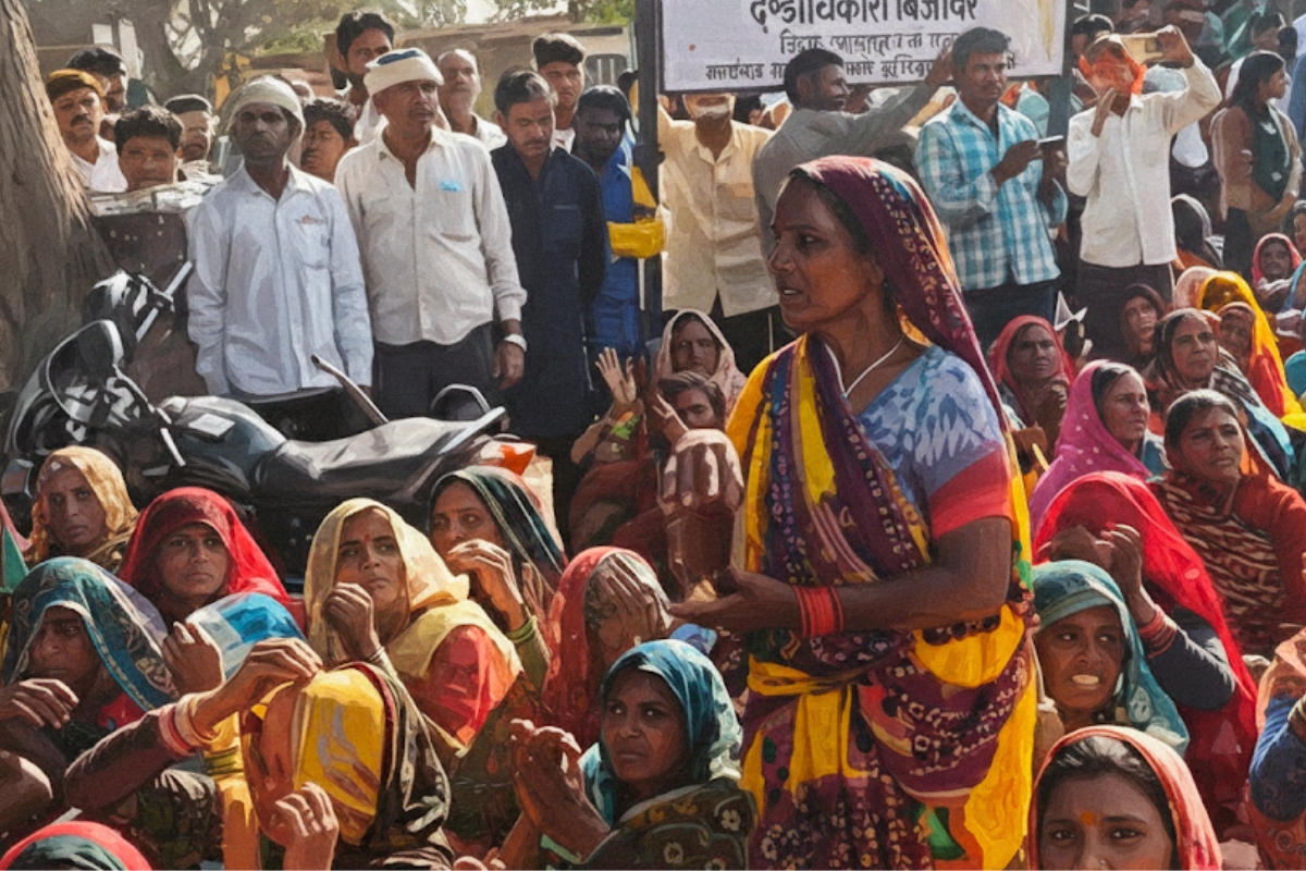
Three months of unrest in Ujjain ended when the Madhya Pradesh Government withdrew the land pooling plan for the Simhastha area. Farmers had opposed the scheme, arguing that it would take away their land and change the character of the pilgrimage zone. The cancellation came hours before a large protest called by the Bharatiya Kisan Sangh. Thousands of farmers from 18 districts were preparing to reach Ujjain with tractors, bedding, and supplies.
The land pooling plan was originally introduced under the Madhya Pradesh Integrated Township Policy, 2025. The government said it wanted to create long-term infrastructure for the 2028 Simhastha. The idea was to use land pooling to build roads, water networks, drainage, electricity lines, gardens, akhara spaces, and public services across more than 2,300 hectares. The Ujjain Development Authority framed the scheme, and Chief Minister Mohan Yadav backed it.
As protests grew, the Kisan Sangh met the Chief Minister in Bhopal and placed four demands. These included withdrawal of the land pooling plan, cancellation of related notifications, withdrawal of all cases against farmers, and a ban on permanent construction in the Simhastha zone. “The central leaders of the Kisan Sangh clearly stated that the Land Pooling Act in the Simhastha area must be withdrawn,” said BKS leader Rahul Doot. After several rounds of talks, the government accepted all demands and asked officials to cancel the scheme.
What is Land Pooling?
Land Pooling in Madhya Pradesh is defined under the Integrated Township Policy, 2025. The policy does not create a separate “Land Pooling Act” but introduces land pooling as a method to plan large townships. It is a tool that allows landowners and private developers to combine their land for large-scale development. After pooling, the land is reorganized into a planned layout with roads, parks, public facilities, and residential and commercial zones.
The policy aims to use land pooling to support township projects where public and private groups share responsibilities. Landowners contribute their land to form a single project area. Developers plan and build the infrastructure. In return, landowners receive a reconstituted share of developed plots. This method is meant to bring order to city expansion and reduce scattered, unplanned growth.
The policy views land pooling as a way to supply prepared land for housing and services. It seeks to shift away from long delays in land acquisition and ease the pressure created by the state’s rising urban population. Madhya Pradesh wants to use this tool for planned townships that include essential facilities, better roads, and mixed-use areas.
Why is Land Pooling Mechanism Needed?
The state faces a rising demand for housing and city-level services. Many areas have grown without planned roads, water lines, or open spaces. The government argues that earlier models for land development involved lengthy procedures. These delays limited the supply of land and slowed down new housing.
Land pooling offers a different approach. It allows faster land assembly and promotes private participation. The state expects this method to support affordable housing, new jobs, and better infrastructure. The policy draws from experiments in states such as Maharashtra, Gujarat, and Rajasthan, where township projects attracted private investment and sped up land development for housing.
The mechanism also reduces the burden on developers. Instead of purchasing all land upfront, developers can combine land through agreements with landowners. This lowers the capital required at the start of a project. The government sees this as a way to open more land for construction while ensuring that basic services and public spaces are built into the layout.
How Land Pooling Works
The land pooling process starts when a developer or group of landowners proposes a township. The land must meet the minimum size set by the policy. In smaller cities with less than five lakh people, the land must be at least 10 hectares. In larger cities, the minimum is 20 hectares. If the township is outside urban limits, the minimum is 40 hectares.
Developers must register with the state. They must also meet financial conditions tied to project size, except when the landowners themselves take up the development. The land must be free of legal disputes. Areas such as forests, sanctuaries, defence zones, and archaeological sites cannot be used.
The developer is expected to assemble most of the land through negotiation. If the developer secures 80 percent of the land but is unable to buy the remaining parcels, the state may step in to help. When government land falls inside the proposed area, the state can give up to 20 percent of the total land or up to eight hectares. The developer pays a premium for this land and must return half of it as a reconstituted plot for mixed use.
The policy offers several incentives to developers. These include benefits under Transferable Development Rights, relaxation of rules for colony layout, and extra construction rights for creating wooded areas, using renewable energy, or building affordable housing. The base Floor Area Ratio is set at 1.00, but developers can purchase additional FAR up to 100 percent.
Eligibility Criteria
Township projects must follow land size and location rules. Land should be contiguous. It cannot include water bodies, bio-sensitive zones, or protected monuments. Developers must prove financial capacity based on land area. They must also hold clear ownership records.
The eligibility norms aim to prevent fragmented layouts and ensure that only groups capable of delivering the project move forward. Landowners can also form associations and act as developers without meeting financial norms. This gives them the option to participate directly rather than surrender land fully to private builders.
Rulings on Land Distribution
The policy sets clear land use rules. Residential use in townships of 10 to 40 hectares can cover up to 60 percent of gross area, while larger townships can use up to 65 percent. At least 10 percent of the area must be kept as parks and open spaces, including a continuous wooded belt equal to 2.5 percent of the gross area. Social and physical infrastructure must cover at least 5 percent of the area. Fifteen percent of all housing units must be reserved for the Economically Weaker Section and Low-Income Group.
The land use distribution varies slightly depending on whether the township area is 10 to 40 Hectares or 40 Hectares and above:
| Land Use Category | Townships 10 to 40 Hectares (Maximum 60% Gross Area) | Townships 40 Hectares & Above (Maximum 65% Gross Area) |
| Residential (of Saleable Area) | Maximum 80%. 15% of total units reserved for EWS/LIG, free from FAR. | Maximum 75%. 15% of total units reserved for EWS/LIG, free from FAR. |
| Work Center (of Saleable Area) | Minimum 20% (for commercial, IT/ITES, educational, health, etc.). | Minimum 25% (for commercial, IT/ITES, educational, health, etc.). |
| Other Public Purpose Area (of Gross Area) | Minimum 40% (Includes parks, open spaces, amenities, road circulation). | Minimum 35% (Includes parks, open spaces, amenities, road circulation). |
| Parks and Open Spaces | At least 10% of the gross area (minimum 25% of this 10% area—i.e., 2.5% of gross area—must be developed as continuous wooded area). | At least 10% of the gross area (minimum 25% of this 10% area—i.e., 2.5% of gross area—must be developed as continuous wooded area). |
| Amenities | At least 5% of the gross area for social and physical infrastructure (education, health, transport, power, gas, water, etc.). | At least 5% of the gross area for social and physical infrastructure. |
Implementation Procedure (How it Works)
The process runs in two stages. First, the developer submits a preliminary report covering land details, proposed land use, infrastructure plans, financial viability, and expected needs for state support. A committee examines the proposal. If accepted, the developer gains preliminary approval but cannot begin construction.
The second stage requires a detailed project report. This must be filed within six months unless changes in the city’s development plan are needed. After final approval, the developer must begin work within six months.
A single-window system helps developers secure required clearances. If a department fails to provide approval within 60 days, the case is sent to a higher committee.
Final projects are expected to include all planned roads, utilities, parks, and public facilities. Landowners receive reconstituted plots as per agreed shares. The rest of the land becomes saleable property for the developer.
The Land Pooling mechanism under the Madhya Pradesh Integrated Township Policy, 2025, lays out a structured method to combine land, reorganize it, and build large township projects.
Support us to keep independent environmental journalism alive in India.
Keep Reading
Small Wild Cats in Big Trouble: India’s First National Report Released
Forest Diversion Crosses 78,000 Hectares, Afforestation Lags
Stay connected with Ground Report for underreported environmental stories.
Follow us onX, Instagram, and Facebook; share your thoughts at greport2018@gmail.com; subscribe to our weekly newsletter for deep dives from the margins; join our WhatsApp community for real-time updates; and catch our video reports on YouTube.
Your support amplifies voices too often overlooked, thank you for being part of the movement.