India experienced its eighth warmest year on record in 2025, as weather data showed national average temperatures climbing 0.28 degrees Celsius above the 1991-2020 baseline, according to the India Meteorological Department’s Annual Climate Statement released in January 2026.
The year marked a historic shift in India’s climate patterns. Rain-related disasters overtook lightning as the country’s deadliest weather hazard for the first time since records began, claiming 1,372 lives compared to 1,317 lightning deaths.
According to the IMD statement, “At least 2,760 deaths were recorded nationwide during the year.”
How Did Winter Break 124-Year-Old Records?
India recorded its warmest winter in 124 years. The January-February period registered temperatures 1.17 degrees Celsius above normal levels.
February 2025 shattered previous records. The statement mentioned, “February 2025 was the hottest February on record nationally, with an average temperature anomaly of +1.36°C.”
The month also recorded the highest-ever minimum temperature anomaly at 1.20 degrees Celsius and the second-highest maximum temperature anomaly at 1.52 degrees Celsius.
January proved unusually warm as well, registering the second-highest mean temperature anomaly at 0.98 degrees Celsius and the fifth-highest minimum temperature anomaly at 1.04 degrees Celsius since 1901.
For the first time in recorded history, heatwave conditions struck during winter. Goa and Maharashtra experienced India’s first heatwave of the year on February 25, an unprecedented event for the IMD-defined winter season.
Night temperatures rising
Rising minimum temperatures emerged as a critical factor in 2025’s extreme weather patterns. While maximum temperatures have increased faster over decades, nighttime warming played a defining role throughout the year.
Between 1901 and 2025, India’s annual mean temperature rose by 0.68 degrees Celsius per century. Maximum temperatures increased by 0.89 degrees Celsius per century, while minimum temperatures rose by 0.47 degrees Celsius.
The statement mentioned that rising minimum temperatures “are increasingly shaping heat stress, rainfall extremes and multi-hazard disasters.”
Ten of India’s fifteen warmest years since 1901 have occurred between 2011 and 2025. The decade from 2016 to 2025 became the warmest on record, with an average temperature anomaly of 0.32 degrees Celsius.
What Happened During Pre-Monsoon Season?
The pre-monsoon season from March to May measured 0.29 degrees Celsius warmer than normal. May recorded the highest all-India rainfall since 1901 at 126.7 millimeters, while total pre-monsoon rainfall ranked third-highest on record.
Warm nights arrived earlier than expected. On March 15, Odisha and Jharkhand recorded the first warm-night conditions of the year, nearly two weeks earlier than in 2024.
According to analysis by the Centre for Science and Environment and Down To Earth, extreme-event days rose from 88 percent of the pre-monsoon season in 2022 to 99 percent in 2025.
The excess rainfall triggered flash floods and landslides. Heavy rain, floods and landslides occurred on 51 of 59 winter days, creating widespread damage before the monsoon season officially began.
Monsoon Floods Cause Most Damage
During the southwest monsoon from June to September, average temperatures remained 0.09 degrees Celsius above normal. National rainfall stood at 108 percent of the Long Period Average, but distribution proved highly uneven.
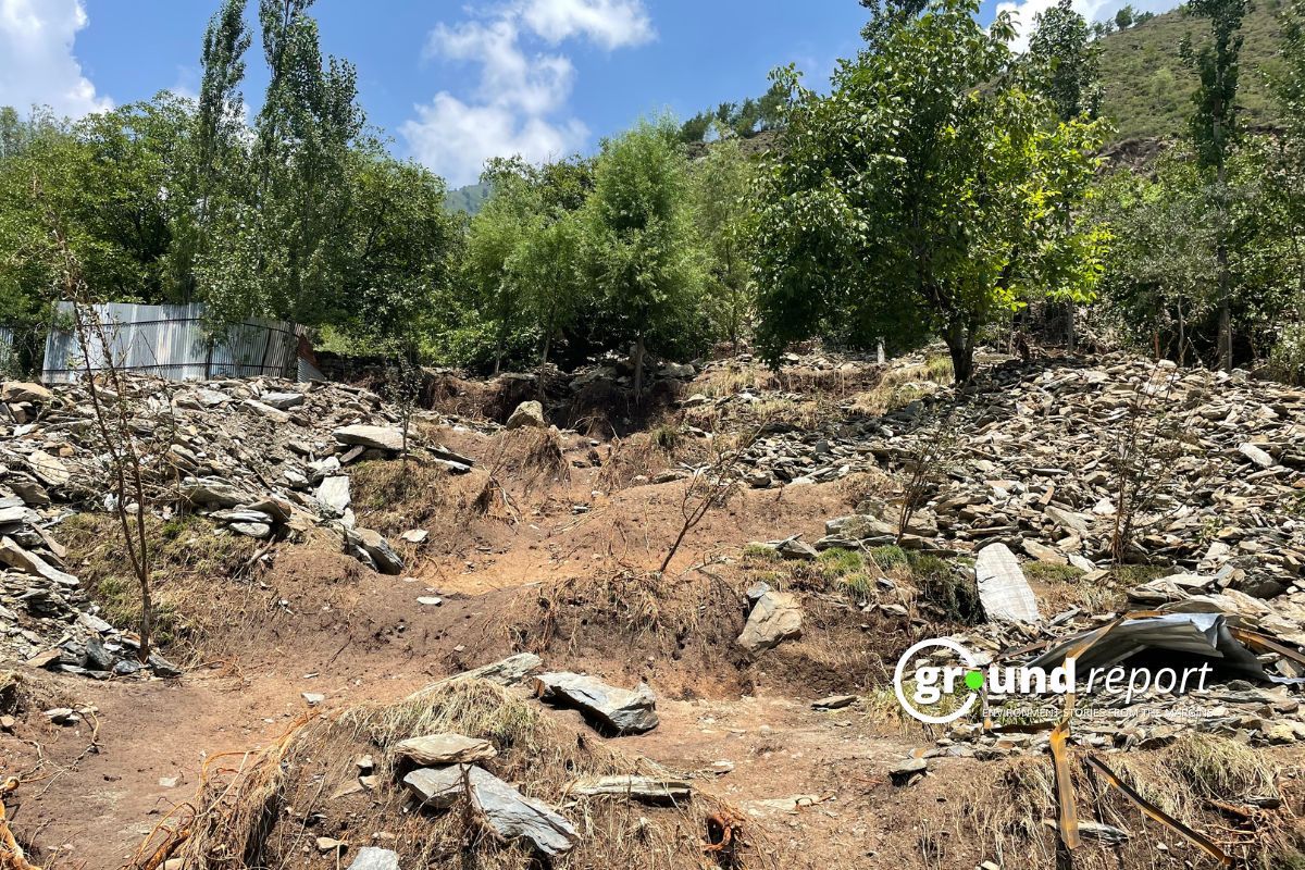
Northwest India received 127 percent of its average rainfall, with intense precipitation concentrated in late August and early September. Flash floods severely affected Himachal Pradesh, Jammu and Kashmir and Punjab.
The IMD statement noted that Punjab experienced its worst floods since 1988. Himachal Pradesh recorded heavy to extremely heavy rainfall on 98 of 122 monsoon days.
Central India and the southern peninsula also recorded surplus rainfall at 115 percent and 110 percent of average levels respectively. East and Northeast India faced deficit monsoon conditions at just 80 percent of average rainfall.
When Did Cold Waves Arrive This Year?
The post-monsoon season from October to December measured slightly cooler than normal, with an average anomaly of minus 0.10 degrees Celsius. However, extreme weather events continued.
Cold waves arrived earlier than in any year since 2022 and affected wider geographic areas. For the first time in four years, cold-wave conditions were reported in 13 states across all four regions.
Rainfall during the post-monsoon season exceeded normal levels at 111 percent of the Long Period Average. Cyclone Montha and localized intense rainfall events killed at least 300 people.
How Accurate Were Forecasts in 2025?
While extreme weather intensified, the India Meteorological Department demonstrated significant improvements in forecast accuracy throughout 2025.
According to the IMD statement, “A comprehensive suite of operational weather bulletins, advisories, outlooks, and specialized forecasts were issued by National Weather Forecasting Centre on a daily, weekly, and event-based basis.”
The department issued 1,460 All India Weather Bulletins and an equal number of Severe Weather Warning Bulletins throughout the year, ensuring continuous national-scale weather monitoring.
Heavy rainfall forecasts showed high skill levels. The statement mentioned that Day-1 forecasts achieved a Probability of Detection of 0.85, Critical Success Index of 0.60, and Percent Correct of 0.75.
Thunderstorm nowcast accuracy improved dramatically over the past decade. The Probability of Detection increased from approximately 0.67 in 2013 to 0.92 in 2025, while the False Alarm Ratio dropped from 0.37 to 0.27.
Heat wave forecasts maintained very high accuracy for short lead times. Day-1 values consistently remained between 95 and 98 percent during 2021 to 2025, indicating excellent detection capability.
Cold wave forecasts showed strong capability at short lead times. Day-1 values ranged from approximately 85 to 94 percent across recent winters.
The IMD issued more than 400 expedition forecast bulletins supporting national mountaineering and defense expeditions. The department also produced 740 mountain weather bulletins for the Western and Central Himalayan regions.
Why Rain Replace Lightning as India’s Top Killer?
The five warmest years on record remain 2024 at 0.65 degrees Celsius above average, 2016 at 0.54 degrees Celsius, 2009 at 0.40 degrees Celsius, 2010 at 0.39 degrees Celsius, and 2017 at 0.38 degrees Celsius above the baseline.
Despite winter rainfall measuring just 52 percent of the Long Period Average, making it the fifth driest January on record, extreme events occurred widely across the country.
The shift in deadliest climate hazards from lightning to rain-related disasters signals a fundamental change in India’s climate risk profile. Intensifying rainfall extremes across multiple seasons have emerged as the nation’s most lethal climate threat, requiring enhanced preparedness and response systems for floods and landslides throughout the year.
Support us to keep independent environmental journalism alive in India.
Keep Reading
Small Wild Cats in Big Trouble: India’s First National Report Released
After Tragedy, Families Face Delays in Tiger Attack Compensation
Stay connected with Ground Report for underreported environmental stories.