हिंदी में पढ़ें। The Bandhavgarh Tiger Reserve in Umaria district of Madhya Pradesh is connected to the Achanakmar Tiger Reserve in Chhattisgarh through a wildlife corridor that passes through the Ghunghuti forest range. India’s Forest Advisory Committee (FAC) has granted in-principle approval (Stage-I clearance) for underground coal mining near the entrance of this corridor.
The approval has drawn scrutiny because the proposed mine lies just 500 metres from a functional wildlife corridor linking Bandhavgarh and Achanakmar tiger reserves. An area critical for tiger movement and genetic exchange. While the government argues that underground mining and the lack of technically viable non-forest land—due to flood risks in low-lying areas—justify the project, experts say the associated infrastructure, traffic, and disturbance could still fragment the corridor and weaken connectivity in this key tiger landscape.
What is the issue?
The case concerns the Ghunghuti forest range in Pali tehsil of Umaria district in Madhya Pradesh. A mining project has been proposed here for the Pathora West coal block (Sohagpur coalfield).
For this project, M/s Shri Bajrang Power and Ispat Limited had sought 149.6878 hectares of forest land. Of this, 130.187 hectares is designated for underground mining, while 19.50 hectares will be diverted for surface infrastructure, including roads, office buildings, coal storage areas, and related facilities.
The proposal was placed before the advisory committee of the Ministry of Environment, Forest, and Climate Change on January 22, 2026. The documents presented to the committee show that the state government acknowledged that wildlife such as tigers, leopards, sloth bears, and chital are regularly seen in the area.
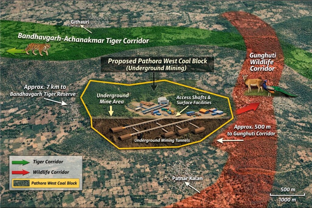
What is surprising is that the state government itself admits that the proposed mining site lies adjacent to the Bandhavgarh–Achanakmar wildlife corridor. The proposed mining site is only 0.5 kilometres (500 meters) away from the Ghunghuti wildlife corridor. This corridor further connects to the sensitive Bandhavgarh–Achanakmar wildlife corridor, located about 7.1 kilometres away. Despite this acknowledgment, the committee approved the proposal in its January 22, 2026, meeting, recommending the diversion of 149.6878 hectares (about 370 acres) of forest land in favour of M/s Shri Bajrang Power and Ispat Limited.
Experts who have worked in wildlife conservation say the government has ignored its own guidelines. The National Tiger Conservation Authority (NTCA) and the Supreme Court have clear guidelines stating that heavy industrial activity near corridors connecting two tiger reserves should either be prohibited or strictly regulated.
Ajay Dubey, an environmental activist from Madhya Pradesh and founder of the Prayatna organization, calls this decision a “criminal conspiracy against wildlife.”
“When officials themselves are stating in writing that this area is adjacent to the corridor connecting Bandhavgarh and Achanakmar, why was it not declared a ‘no-go zone’?” Dubey adds, “A corridor is not just a single pathway. It is the lifeline of genetic flow for tigers. Mining will create an edge effect—noise from trucks, 24-hour lighting, and blasting vibrations. All of this will permanently drive tigers away from the area.”
Importantly, ‘No-Go Zones’ are determined based on ecological sensitivity, forest density, wildlife corridors, or security concerns. The Environment Ministry restricts mining in dense forests (Category A), while controlled mining is permitted in less sensitive areas (Category B). This classification is meant to ensure ecological conservation.
Underground mining: the biggest illusion
The project was justified because it involves underground mining, which is said to cause less surface damage to forests. However, environmentalists argue that this claim is misleading. Project documents clearly state that 19.50 hectares of forest land will be used for surface infrastructure. This includes a coal dump area, an electrical sub-station, ventilation shafts, a weighbridge, and workshops for heavy machinery.
“Will the coal from inside the mine fly out through the air? There will be long lines of trucks outside, thousands of workers moving in and out. Will the forest remain intact then?” Senior environmental lawyer Sudip Shrivastava says.
He further adds, “Underground mining can often be more dangerous than open-cast mining. It works like an invisible cancer—you hollow out the land from below and expect the trees above to stand. It is a mockery of both science and nature.”
Several scientific studies also support this concern. According to these studies, the impacts of underground mining often appear gradually. Over time, land subsidence, soil degradation, and ecological damage increase, and the effects may continue for decades.
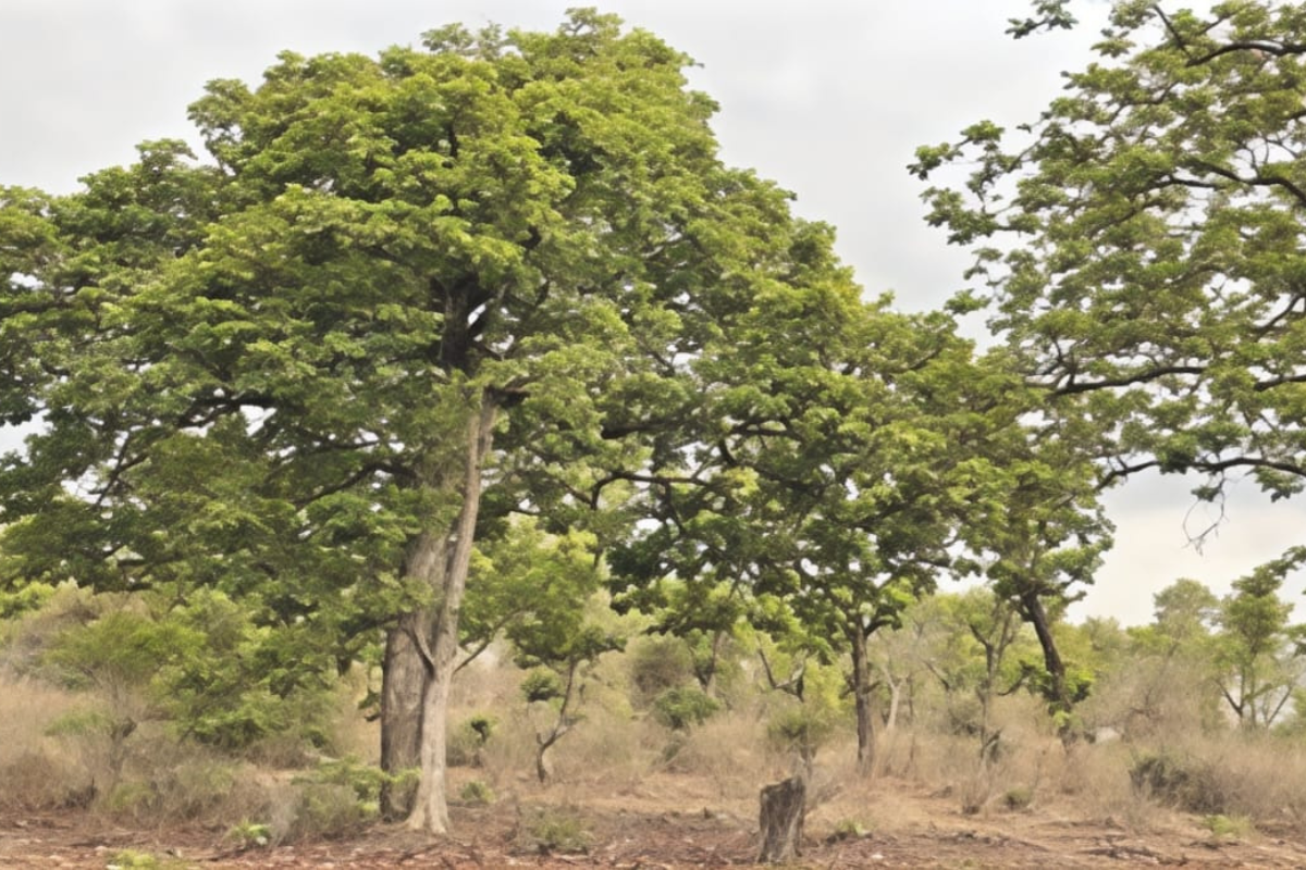
1,753 trees will be cut for the project
The project seeks permission to fell 1,753 trees, including mahua, char (chironji), jamun, sal, and teak. According to the forest department, the area has a forest density of 0.6—classified as Eco Class-III—indicating a moderately dense and ecologically mature forest.
“This [tree felling] will destroy habitats for countless species. Labeling this forest as Eco Class-III is the forest department’s biggest dishonesty,” local wildlife activist Adil Khan says.
No alternative land available
Before the committee, the state government argued that no technically feasible alternative land was available for the project’s infrastructure. This claim was based on a hydrological assessment conducted by NIT Raipur.
According to the report, the terrain of the Pathora West coal block is uneven, with elevations ranging between 480 metres and 548 metres. The Bijora stream also passes through the area. The report notes that the highest flood level (HFL) of this stream is about 501.34 metres.
The government argued that the available non-forest land mostly lies in the lower areas near the stream, which are prone to flooding. Officials said that if the mine entrance—such as a shaft or incline—was built in these low-lying areas, rainwater from the stream could flood the underground mine during the monsoon. Therefore, the government said that placing the mine entrance in higher forest land was chosen to avoid flood risks.
“Is it justified to endanger a wildlife corridor to ensure corporate profits and protect them from flooding?” Deepmala Patel, Program Associate (Energy) at the Centre for Financial Accountability, strongly criticizes this reasoning, calling it pro-corporate. “If no safe non-forest land was available, why was the project not cancelled altogether? Is 0.8 million tonnes of coal more valuable than the future of India’s national animal—the tiger?”
As of 2022, India is home to over 3,000 tigers, with Madhya Pradesh—often called the “tiger state”—hosting more than 500 of them. The Madhya Pradesh government highlights the rising tiger population and promotes tourism. At the same time, the Forest Advisory Committee has granted in-principle approval for the diversion of around 150 hectares of forest land and the felling of 1,753 trees in an area adjacent to the Bandhavgarh–Achanakmar corridor.
In an earlier report, we highlighted the importance of wildlife corridors, and many are fragmented across Madhya Pradesh. This fragmentation could be contributing to rising human–wildlife conflict. These corridors already face other human pressures like agriculture, livestock grazing, etc.
The final decision now rests with the Ministry of Environment, Forest and Climate Change (MoEF&CC), which must decide whether to grant Stage-II clearance. Environmentalists and conservation groups are demanding a reconsideration of this decision.
Support Us To Sustain Independent Environmental Journalism In India.
More Ground Reports
Panna: Villagers Protest Irrigation Projects, Demand Documents, and Transparency
Fulkai Maai Demands the Return of Crèches for Malnourished Korku Children
Stay Connected With Ground Report For Underreported Environmental Stories.
Support Us To Sustain Independent Environmental Journalism In India.