Cyclone Biparjoy, initially classified as a very severe cyclonic storm, weakened to a severe cyclonic storm after hitting coastal areas of Gujarat on Thursday night, according to the India Meteorological Department (IMD).
The NDRF report on Friday confirmed two deaths and 23 people were injured and 24 animals lost their lives due to Cyclone Biparjoy in Gujarat. The National Disaster Response Force (NDRF) confirmed that two human lives were lost before the cyclone made landfall.
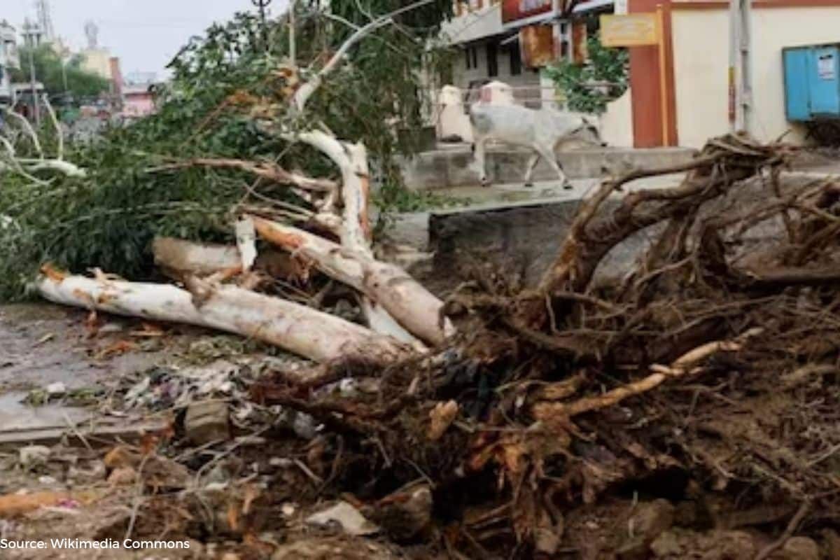
Alok Pandey, the Relief Commissioner, stated that approximately 22 people were injured during the storm. Fortunately, there have been no reported deaths thus far. 524 trees were uprooted, and power poles fell in some areas, causing power outages in 940 villages.
As Cyclone Biparjoy moved northeast, heavy rain was expected in Rajasthan after it crossed Saurashtra-Kutch and the adjoining coast of Pakistan. However, the intensity of the cyclone has decreased.
Mrutyunjay Mohapatra, Director of IMD, explained that Cyclone Biparjoy tore through the Saurashtra-Kutch region near Jakhau port in Gujarat before moving from sea to land. The cyclone’s intensity has decreased to 105-115 km/h, causing its classification to change from Very Severe Cyclonic Storm (VSCS) to Severe Cyclonic Storm (SCS). Rajasthan may experience heavy rain on June 16.
Biparjoy forecast
According to the latest IMD update, Cyclone Biparjoy is forecast to weaken to a severe cyclonic storm with wind speeds of 105-115 kmph, gusting to 125 kmph, later tonight. By early Friday, it is expected to weaken further to a cyclonic storm with wind speeds of 80-90 kmph, gusting to 100 kmph. By noon Friday, it is likely to become a deep depression with winds 50 to 60 km/h gusting to 70 km/h, and by Friday night, it is expected to become a depression with winds from 35 to 45 km/h, with gusts of 55 km/h.
The de-intensification is a common occurrence, as cyclones experience increased friction, disruption of the supply of heat and moisture, and loss of their warm core structure after crossing from sea to land.
Gujarat has already experienced significant rainfall due to Cyclone Biparjoy. In the 11-hour period between 8:30 a.m. and 5:30 p.m. and 7:30 p.m. on the day it made landfall, several regions recorded considerable rainfall, including Bhuj (74mm), Naliya (42mm), Kandla (30mm), Porbandar (28mm), Dwarka (29mm) and Okha (20mm), according to reports the IMD.
There have also been reports of falling tree incidents causing injuries. At least three people were injured in tree-falling incidents in Gujarat’s Devbhoomi Dwarka district during the oncoming cyclone Biparjoy, according to TOI.
Impact of Cyclone Biparjoy
Narendra Singh Bundela, the Inspector General of the National Disaster Response Force (NDRF), has indicated that the areas likely to bear the brunt of the impact of Cyclone Biparjoy are the Kachchh region of Gujarat and the southern parts of Rajasthan. He warned of heavy downpours and possible flooding in these areas.
Manorama Mohanty, director of the IMD regional meteorological center in Ahmedabad, provided an update on the landfall process, stating that the wall cloud region of the cyclone has already touched the Saurashtra region. This region is experiencing strong winds and heavy rains, with an approximate circulation diameter estimated to be around 300-350 km.
Looking ahead, southwestern Rajasthan is expected to witness heavy to very heavy rain, with extremely heavy downpours in isolated spots on June 16-17, as Cyclone Biparjoy continues its north-eastward motion inland. Heavy precipitation is forecast to gradually spread towards south-eastern Rajasthan by Saturday.
The landfall of Cyclone Biparjoy, with wind speeds of around 110-120 kmph, gusting to 135 kmph, started over Gujarat at approximately 6:45 PM.
The coastal areas of Gujarat have already experienced heavy rain and strong winds throughout the day. Notable rainfall amounts include Bhuj (61mm), Naliya (32mm), Kandla (30mm), Porbandar (28mm), Dwarka (23mm) and Okha (19mm). Several locations also recorded significant wind speeds during this period.
Keep Reading
- What is landfall of a cyclone, How long does it last?
- Biporjoy Cyclone: Gujarat Cut Its Budget For Natural Calamities By 71%
- Extreme Weather Update: Heavy Rainfall And Strong Winds Expected
- Biporjoy Only Cyclone Making Strong Landfall In Gujarat Since 1965
Follow Ground Report for Climate Change and Under-Reported issues in India. Connect with us on Facebook, Twitter, Koo App, Instagram, Whatsapp and YouTube. Write us on GReport2018@gmail.com.